Over the weekend, Timberline Adventures concluded one of our favorite trips of the year; the Rocky Mountain National Park six day hiking tour, where we take guests exploring all over Rocky Mountain National Park. The peaks and valleys are stunning and we can always anticipate an abundance of wildlife. With Colorado being a land-locked state, fresh water attractions become that much more enticing; on our recent tour in Rocky Mountain National Park, we visited water features every day. We’ve included a few of our favorite aspects of the trip and hope you enjoy the scenery as much as we did.
Wild Basin Area
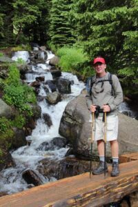
Day One: our first introduction to the Rocky Mountains was hiking in the Wild Basin area. There are more locals here than tourists, as the trailhead is away from the congested areas of Estes Park. Within a few minutes of leaving the ranger station, we were hiking along the North St. Vrain Creek, which tumbles from the snowfields and high alpine lakes above 12,000 feet. Our destination was Ouzel Falls, along Ouzel Creek, both named for the tiny Ouzel dipper bird that frequents the area. The sturdy bridge crossing the creek, rebuilt after the infamous flood of 2013, gives a beautiful vantage point (and cooling mist) of this wilderness waterfall as it cascades down among rocks and fallen logs, rushing towards the valley below.
Odessa Gorge
Day Two: on the second day, threatening thunderclouds kept us away from higher elevations, so we took a point-to-point route along a string of lakes through the spectacular Odessa Gorge. Starting from Bear Lake, the poster child lake of the park at an elevation of 9,500 feet, we climbed up over a rib of Flattop Mountain and into the Fern Creek valley. The view from Lake Helene, nestled in a glacier-carved depression through the steep-walled gorge, is breathtaking.
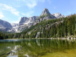 Although both ends of this trail are popular areas, few people make it to the middle of the trail to witness the multitude of waterfalls plunging from the peaks of Notchtop, Knobtop, and Little Matterhorn. The waters collect in Odessa Lake, whose calm surface disguises the turbulent journey the waters have taken so far. Reflections of the looming peaks in the area demand an obligatory photo stop. After this respite, we continued to descend along Fern Creek, past Fern Lake, Marguerite Falls, Fern Falls, and The Pool before reaching the lower trailhead.
The Diamond – Longs Peak
Day Three: we enjoyed a spectacular climb to the base of The Diamond, an infamous diamond shaped vertical wall comprising the east face of Longs Peak, the only mountain above 14,000 feet in the park. This sheer rock face – with coveted rock climbing routes of up to 10 pitches – points directly down to a deep snow-filled pocket called Chasm Lake. The hike to the lake is not technical, but we did ascend 2,500 feet
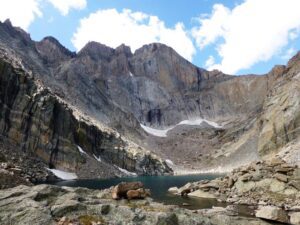 through boulder and scree fields to reach a point well-above timberline. The lake was hidden until we crested the moraine on the flank of Mt. Lady Washington. We then had to descend into a secluded alpine basin before hiking up the headwall that forms the lake. While enjoying lunch by the water, we could shift our gaze from the clear view, to the bottom of the icy lake, to the technical climbers dangling by rope from the rock face above.
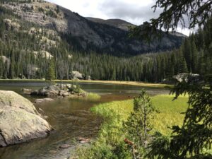
Sky Pond – Alberta Falls
Day Four: our next day brought another alpine lake destination – Sky Pond (aptly named). This trail starts at the popular Glacier Gorge trailhead and follows Glacier Creek up valley. The photogenic Alberta Falls is just a short way up the trail, and beyond that the crowds thin considerably. We continued up the glaciated valley to Loch Vale (Lake of the Valley). Above this, the climbing really began until we reached the first headwall. Timberline Falls spills out from the lakes above, shrouding the area in mist. A bit of a scramble beside these falls brought us to Lake of Glass. The beauty of the reflective waters was enticing, but the trail called us on. Finally, after a pleasant walk
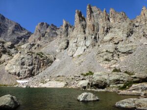
through moraines and creek beds above tree line, we reached Sky Pond. From this water-filled cirque, the mountains meet the sky, the seasons meld together with the ever-present snow and sun, and you can truly set free your cares in this ethereal world.
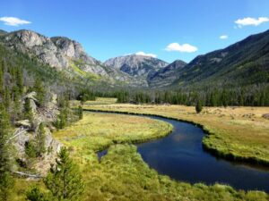
Grand Lake
Day Five: we ventured to the west side of Rocky Mountain National Park. We started from the shores of Grand Lake near the resort town of the same name. After a quick detour to view Adams Falls, we continued up the gentle valley along East Inlet. This side of the park seems quieter and more serene. The trail follows the mellow stream through pine forests and marshland that is frequented by moose and deer. Farther along the trail, the grade got steeper, and the sight of Lone Pine Lake was welcome. Sitting by its quiet shores and looking across at the tiny island with one lone pine tree, the last of the stressors of daily life melted away.
Trail Ridge Road
Day Six: for one last blissful morning, we enjoyed the heights of Rocky Mountain National Park. This day required a drive back over Trail Ridge Road – the highest continuously paved road in the country. By car, we climbed up through the three life zones of the park: the montane zone including the pine and aspen forests and meadows in the Kawuneeche Valley, where deer, elk, moose, beaver, coyote and countless squirrels and birds abound; the subalpine zone where the evergreen trees start to thin and the wildflowers flourish, attracting some of the hardier, smaller animals; and up to the alpine zone where gnarled trees disappear altogether and tundra grasses and delicate wildflowers hide between patches of snow.
It was here that we started our last hike, on the Continental Divide at Milner Pass, caught between Poudre Lake and the headwaters of the Colorado River. To the west, the trickle of water starts its journey down to become a small stream, then a babbling brook, then a winding creek in and out of lakes, and eventually into the renowned Colorado River. To the east, the wind-swept Poudre Lake feeds the Cache La Poudre River, which travels north and east through the park, dumping out onto the eastern plains of Fort Collins, where it will meet the South Platte River, and finally, the Mississippi River, as it flows into the Gulf of Mexico. Leaving the lake, we climbed through the alpine tundra to intersect the road at the Alpine Visitor
 Center. From there, we could look out over the heights of the park, across the snowfields, glaciers and crystal blue alpine lakes that fill the reservoirs below to provide the magnificent and life-providing resource that is water.